Se afișează postările cu eticheta Maps. Afișați toate postările

Transsilvania

Title : Transsilvania
Cartographer : Petrus Bertius
Date : 1603
Dimensions : 16,0 x 11.3


Taken from "Petrus Bertius, Tabularum Geographicarum Contractarum", the 1603 edition. Engraving dimensions : 12.5 x 8.7 cm.

Gravura luata din "Petrus Bertius, Tabularum Geographicarum Contractarum", editia de la 1603. Dimensiunea gravurii : 12.5 x 8.7 cm


Transsylvanie

Title : Transsylvanie
Author : Sebastian Münster
Date : 1552
Dimensions : 31,6 x 21,2 cm


This is an engraving from the french first edition of "Cosmographia", in Basel. The engraving's size is 15,0 x 18,8 cm.


Aceasta este o gravura din prima editie franceza a "Cosmographia", din Basel. Gravura are dimensiunile 15,0 x 18,8 cm.


Descriptio Transsylvaniae


Title : Descriptio Transsylvaniae
Cartographer : Petrus Bertius
Date : 1603
Dimensions : 18,3 x 11,0 cm


This is a map from  P. Bertii tabularum geographicarum contractarum libri quinque, cum luculentis singularum tabularum explicationibus apud Cornelium Nicolaj, Amstelodami 1603, written in latin.The engraving's dimensions are 13,3 x 9,3 cm. 


Aceasta este o harta din  P. Bertii tabularum geographicarum contractarum libri quinque, cum luculentis singularum tabularum explicationibus apud Cornelium Nicolaj, Amstelodami 1603, scrisa in latina. Dimensiunile gravurii sunt 13,3 x 9,3 cm.


Dace and Thrace


Title : Dace and Thrace
 Cartographer : Alain Manesson Mallet
 Date : 1683
 Dimensions :  14,2 x 20,9 cm


This is a copper engraving out of the work "Description de l'univers" by Mallet. The map shows the Balcanic Peninsula in the 1st century A.D.,  Dacia, at north of Danube and Tracia, south of Danube. The engraving's dimensions are 11,3 x 15,6 cm. 


Aceasta este o gravura din cartea "Description de l'Univers" de Mallet.  Harta prezinta Peninsula Balcanica in secolul I era noastra, Dacia, situata in nordul Dunarii, Tracia, situata in sudul Dunarii. Dimensiunile gravurii sunt 11,3 x 15,6 cm. 


Illyrie


Title : Illyrie
Cartographer : Alain Manesson Mallet
Date : 1683
Dimensions : 12,8 x 19,2 cm


This is a copper engraving out of the work "Description de l'univers" by Mallet. The map shows Illyrie and its neighbours: Greece, Moesia, Pannonia, Noricum and Italy. The leaf dimensions are 12,8 x 19,2 cm and the map dimensions are 11,3 x 14,3 cm.


Aceasta este o gravura din cartea "Description de l'Univers" de Mallet. Harta arata Illyria si vecinii sai: Grecia, Moesia, Pannonia, Noricum si Italia. Dimensiunile foii sunt 12,8 x 19,2 cm iar dimensiunile gravurii sunt 11,3 x 14,3 cm.


Transsilvanie Siebenburgen


Title : Transsilvanie Siebenburgen
 Cartographer : Gerard Mercator 
 Date : 1630
 Dimensions : 26,8 x 19,2 cm


This map is taken from the 1630's french edition of Mercator-Hondius (Jodocus Hindius) book, printed in Amsterdam.  It shows the region of Transylvania in Romania, as well as the adjacent areas of Hungary and Wallachia. The map dimensions are 25,0 x 17,9 cm


Aceasta harta este luata din editia franceza de la 1630 a cartii lui Mercator-Hondius (Jodocus Hindius), tiparita in Amsterdam. Arata regiunile din Transilvania cat si zonele adiacente acesteia,Ungaria si Valahia. Dimensiunile gravurii sunt 25,0 x 17,9 cm.


Moldavie Transilvanie.

Title : Moldavie Transilvanie.
Cartographer : Alain Manesson Mallet
Date : 1683
Dimensions : 20,6 x 13,6 cm


This map is taken from the 1683's french edition of the "Description de l'Univers", one of the earliest printed miniature, illustrated world history/geography books. It illustrates Transylvania, Walachia, Moldavia and a part of Hungary, with a lot of important city names.

Aceasta harta este luata din editia franceza de la 1683 a cartii "Description de l'Univers", una din primele carti miniaturi de geografie si istorie ilustrate . Aceasta arata Transilvania, Valahia, Moldova si o parte a Ungariei, impreuna cu numele oraselor importante de pe teritoriul acestora.


.

Die Siebenburg fo man Funftauch Transilvaniam Nent

Title : Die Siebenburg fo man Funftauch Transilvaniam Nent
Cartographer : S. Munster
Date : 1578
Dimensions : 39,5 x 33,6


The actual engraving has 33,8 x 25,2 cm. It is taken from an edition of Munster’s Cosmographiae Universalis printed in Basel in 1578 by Henrich Petri.
It is hand-colored with beautiful castle drawings, very well preserved.

Gravura propriu-zisa are 33,8 x 25,2 cm. Este luata din editia de la 1578 a Cosmografiei Universale a lui Munster, editata de Henrich Petri in Basel.
Gravura este colorata manual si foarte bine pastrata.


.

Le Royaume de Hongrie Divise en Haute et Basse Hongrie Transilvenie Esclavonie et Croatie

Title : Le Royaume de Hongrie Divise en Haute et Basse Hongrie Transilvenie Esclavonie et Croatie
Cartographer : Jean Janvier
Date : 1762
Dimensions : 36,5 x 49,8 cm


The size of the map is 30,5 x 44,3 cm.
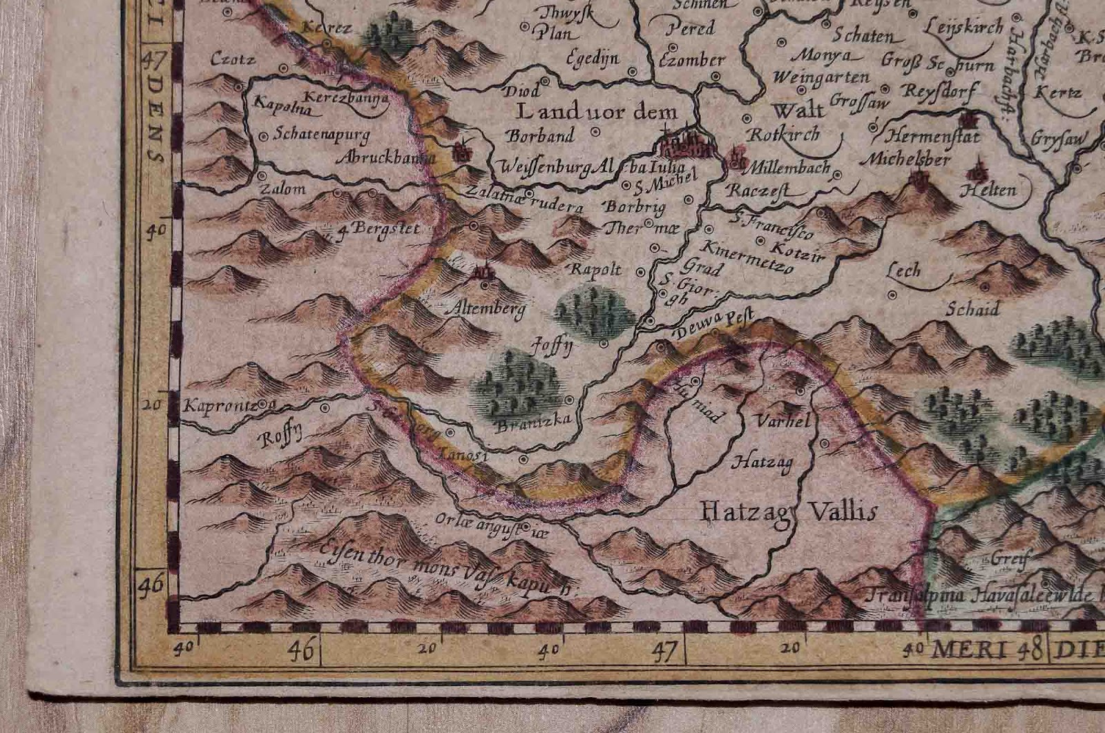
The map is taken from "Atlas moderne ou collection de cartes Sur toutes les parties du Globe..." published by Lattre and Delalain in Paris. The map shows Hungary, Transylvania, Moldavia, Wallachia, Bosnia, Serbia and Bulgaria.


Dimensiunile gravurii sunt 30,5 x 44,3 cm.
Harta este luata din "Atlas moderne ou collection de cartes Sur toutes les parties du Globe..." publicat de Lattre si Delalain in Paris. Harta ilustreaza Ungaria, Transilvania, Moldova, Valahia, Bosnia, Serbia si Bulgaria.


.